Mák’ai
This article or section is in the process of an expansion or major restructuring. You are welcome to assist in its construction by editing it as well. If this article or section has not been edited in several days, please remove this template. If you are the editor who added this template and you are actively editing, please be sure to replace this template with {{in use}} during the active editing session. Click on the link for template parameters to use.
This article was last edited by [[User:miraheze:conworlds>Javants|miraheze:conworlds>Javants]] ([[User talk:miraheze:conworlds>Javants|talk]] | [[Special:Contributions/miraheze:conworlds>Javants|contribs]]). (Update) |
Commonwealth of Mák’ai | |
|---|---|
 Flag
 Emblem
| |
|
Motto: Ga bagair̗ jákang luk'í-parak ga "Our hands shall not be tied" | |
.svg) | |
| Capital and largest city | Mk'ái-t̗ir̗ |
| Official languages | Mák’ai-wa |
| Ethnic groups (2022) |
|
| Demonym(s) | Mák’ai |
| Government | TBD autocracy |
• T'agan | Mar̗uk K’úr̗ai |
• Takiyan | TBD |
• Akitan | TBD |
| TBD | |
• Hazazhan | TBD |
|
TBD TBD | |
| Legislature | Ta'Hazakiyon |
|
Sankazok ∟Taza'Zhazhanin ∟Hakidukor | |
|
Zhahokun ∟Sanka No-Mahuzokin ∟Sanka No-Sankuvanin | |
| Formation | |
• TBD | TBD |
• TBD | TBD |
• TBD | TBD |
• TBD | TBD |
| Area | |
• Total | 635,133 km2 (245,226 sq mi) (68th) |
• Water (%) | 3.2 |
| Population | |
• 2022 estimate | 41,682,419 |
• 2020 census | 41,648,106 |
• Density | 65.6/km2 (169.9/sq mi) |
| GDP (PPP) | 2022 estimate |
• Total | $1,005,692,831 |
• Per capita | $24,128 |
| Gini (2020) |
medium |
| HDI (2022) |
very high |
| Currency | Mák’ai T'ula (₮) (MTL) |
| Date format | dd-mm-yyyy |
| Driving side | right |
| Calling code | TBD |
| ISO 3166 code | MK |
| Internet TLD | .mk |
- This article is part of Project Exodus.
Mák’ai, officially the Mák’ai Commonwealth (Mák’ai-wa: Nbátalak-la Mák’ai, IPA: /n̠bɐ́t̠ɐ̀l̠ɐ̀kl̠ɐ̀ mɐ́kʼɐ̀ɪ/; Kai: Mäkkai Renbona) or the Mák’ai T'aganate (Mák’ai-wa: T'agan-la Mák’ai), sometimes alternatively anglicised as Mak’ai, Makai, or occasionally as Maakkai, is a sovereign state located primarily on the island of Makaigan in central Ejawe, in the north-west of the continent of Aicho on the planet Sabel. It is the world's 68th largest country with a size of 635,133 square kilometres, putting it behind TBD but ahead of TBD.
Etymology
The name Mák’ai is an archaic form of the word for 'people' in the Mák’ai-wa language, itself being the dominant language of Mák’ai. In turn, Mák’ai comes from the Proto-Pan-Ejawan word *mahkeys (IPA: /maʔkejs/), with the meaning of person. This is in turn related to the endonym Mtasai for the Mtasai people of western Ejawe, coming from Proto-Raa-Makaiganic*metahkeysey (IPA: /metaʔkejsej/), 'western people'. *Mahkeys can be further traced back to the Proto-Pan-Ejawan *ham!akteyz (IPA: /hamk͡!aktejz/), which also meant 'people'.
The political entity of Mák’ai has had many different names over its history. In general, however, the term Mák’ai-la is used to refer to the region of Mák’ai influence, with the nominal classifier '-la' indicating 'the region of Mák’ai'. In the current day, Mák’ai is referred to officially as the Mák’ai Commonwealth, or Nbátalak-la Mák’ai. 'Commonwealth' here comes from a direct translation of the Mák’ai-wa word Nbátalak, a compound consisting of nbá, 'good', and talak, 'common'. Alternatively, Mák’ai is also known as the Mák’ai T'aganate, a T'aganate being a state headed by a T'agan. The noun T'agan has its origin in the Proto-Pan-Ejawan word *s'daghn (IPA: /sˀdɑɣn/), which referred to the head of the body.
In other Ejawan languages, Mák’ai is known as Makai (Kto and Imai), Makaizari (Ktazari), Mäkkai (Kai), and Mbakai (Mtasai). Mbakai translates more literally as 'eastern people', and is the common name of Mák’ai in many western Ejawan states.
History
- Main article: History of Mák’ai.
Prehistory
What is now Mák’ai was first settled by modern anatomical humans approximately 70,000 years ago. Emigrating across the Azwanic landbridge from mainland Aicho, in what is today Kaishuri, early humans soon spread westwards across the Ejawan Sea, arriving initially in eastern Makaigan before radiating west and north across the Makaiganic mountain range. These early humans are collectively referred to as the Proto-Pan-Ejawan people, or in certain literature as the Proto-Mtasai-Ktoic people[1], and form the ancestors of all modern-day inhabitants of Ejawe. Some 30-40 thousand years after their initial arrival in Ejawe, geographical isolation as a result of rising sea levels led to the development of three distinctive cultural subgroups of the Proto-Mtasai Ktoic people - the Nga-Hakkhitic people of south-east Ejawe, predominantly on the islands of Hakkhai and Nga; the Ktoic people of eastern Makaigan and the north-eastern Ejawan islands; and the Raa-Makaiganic people of western Ejawe, separated from the Ktoic people by the Makaiganic mountain range. Each of these cultures now formed the primary linguistic and cultural groups that would shape Ejawe's later history.
Geography
- Main articleː Geography of Mák’ai.

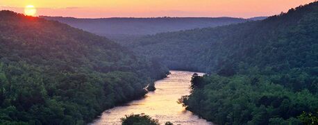
The river T̗ákan̗ in southern Kto, near the Makaiganic mountain range.

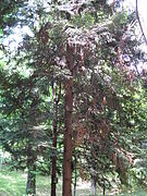
The forests of northern Mák’ai at the foothills of the Makaiganic mountain range.
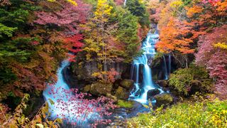
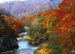
The forests of north-western Makaigan in autumn.
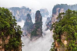
The Valley of It̗ar in southern Kto.
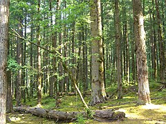
Typical woodland in the warmer regions of Kto.

A road in a typical agricultural area in central Kto.
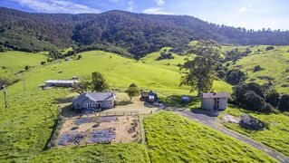
A small homestead in south-central Kto.
The river Lang in northern Kto.
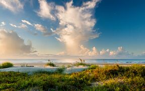
A typical beach in northern Kto.
A small river in Nungái-la.

Winter on the coast of northern Nungái-la.

The south-western coast of Wuk’ái-la in the Sea of Nga.
Typical small islands in the far south of Mák’ai.

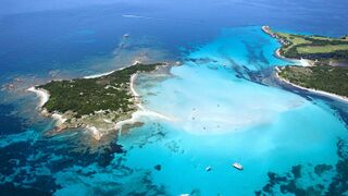
A cove on the island of Mál̗í in the southern Ejawan Sea.


Mák’ai is a principally insular nation, but it maintains a high level of geographic diversity. The majority of the country is located in the southern and central regions of the island of Makaigan, itself the third largest and most central island within the broader region of Ejawe. To the west of Makaigan lies the second largest island in Mák’ai, Nungái-la, which is separated from Makaigan by the narrow Straight of Tigers and has close ties both geographically and historically to Makaigan. The third largest island to make up Mák’ai is Wuk’ái-la, located to the south-east of Makaigan within relatively close proximity to Hakkhai. Mák’ai is further made up of several other smaller islands, generally broken up into three groups - the northern island groups of TBD and TBD, the central island groups of TBD and TBD, and the southern island group of TBD.
The geological history of Mák’ai is largely defined by the interactions between the Ejawan and south-eastern Hakkhitic tectonic plates, whose collision historically formed the Makaiganic mountain range millions of years ago, as well as the emergence of Wuk’ái-la and subsequent development of Ejawan Rift between central and southern Ejawe. This rift in turn resulted in the Kanu line, a geographical barrier that led to the diversification of Ejawan wildlife externally to mainland Aicho. Most of the islands in Mák’ai are mountainous as a result of this tectonic movement. The largest mountain range in Ejawe, the aforementioned Makaiganic mountain range, runs north-south through Makaigan, separating the warmer climactic regions of Kto-la in the east from the cooler Mák’ai heartlands to the west. The Makaiganic mountain range then stretches underwater from the southern coast of Makaigan, and its subsequent peaks form the central Mák’ai islands. Many of these islands were formerly volcanic, and as such are highly fertile. A smaller mountain range also runs north-south through the island of Nungái-la, albeit much smaller in scale to those that divide Makaigan. Outside of these mountainous regions, most of Mák’ai is, or was historically, forested. The north and west of the country in particular is dominated by vast deciduous forests, while much of the eastern coast has been cleared for agricultural use as a result of the region's warmer climate.

As an insular nation, Mák’ai's coasts and waterways have been pivotal in the nation's development. Mák’ai is surrounded by four major bodies of water - to the north, the Northern Ocean; to the west, the Straight of Bones, which separates Nungái-la from Mtasai; to the south, the Ejawan Sea; and to the east, the Sea of Nga. Mák’ai also possesses a number of short but navigable rivers, particularly in the eastern region of Kto-la, where the rivers are sourced from the Makaiganic mountain range. The longest rivers in Mák’ai are the River Mnu, which runs west-east through the island of Nungái-la, and the River T̗ákan̗, which runs south-west through southern Kto-la. These rivers are important sources of water for many of the nation's major agricultural regions and are thereby essential to the Mák’ai economy. As a result of this economic importance, many of Mák’ai's coastal regions and waterways are subject to stringent environmental protections to prevent their degradation through overuse.
Climate
- Main article: Climate of Mák’ai.
Three are three major climactic regions within Mák’ai. The eastern coast of Makaigan as well as Wuk’ái-la and the central islands all possess a humid subtropical climate, characterised by hot and humid summers with cool to mild winters. These are a result of warm oceanic currents moving through the Sea of Nga which heat the areas of Makaigan east of the Makaiganic mountains. The west of the mountains, as well as Nungái-la and the northern islands, have a humid continental climate, characterised by large seasonal differences with very cold winters as a result of cold oceanic currents flowing south from the Koburing circle. The southernmost islands in Mák’ai are characterised by a hot-summer Mediterranean climate, with hot, dry summers and mild, wet winters, primarily as a result of their greater proximity to the equator.
In general, winters in Mák’ai are relatively harsh in the north and west, although much more mild to the south and east of the Makaiganic mountain range. Snow is commonplace in these areas during winter and forms approximately 5-10% of the country's total precipitation per year. Summers tend to come slightly later than in other parts of Sabel, with the warmest months being August, July, and September. September is also the wettest month on average as warm humid conditions dominate most of Mák’ai's subtropical climactic regions. Winters are generally drier than summers although still possess a somewhat high degree of rainfall, as Mák’ai is in general a region of relatively high humidity.
| Climate data for Mák’ai | |||||||||||||
|---|---|---|---|---|---|---|---|---|---|---|---|---|---|
| Month | Jan | Feb | Mar | Apr | May | Jun | Jul | Aug | Sep | Oct | Nov | Dec | Year |
| Average high °F | 53.2 | 51.1 | 57.7 | 66.4 | 73.8 | 79.5 | 85.3 | 88.2 | 81.3 | 73.2 | 61.7 | 53.8 | 68.7 |
| Daily mean °F | 41.5 | 41.7 | 49.1 | 58.1 | 65.8 | 72.7 | 79 | 81 | 74.8 | 65.8 | 54.9 | 46.6 | 61 |
| Average low °F | 29.8 | 32.2 | 40.3 | 49.6 | 57.7 | 65.8 | 72.7 | 73.8 | 68.2 | 58.3 | 47.8 | 39.2 | 52.5 |
| Average precipitation inches | 20.71 | 22.2 | 46.73 | 49.76 | 55.28 | 66.38 | 60.71 | 66.5 | 83.23 | 77.28 | 36.77 | 20.39 | 50.51 |
| Average high °C | 11.8 | 10.6 | 14.3 | 19.1 | 23.2 | 26.4 | 29.6 | 31.2 | 27.4 | 22.9 | 16.5 | 12.1 | 20.4 |
| Daily mean °C | 5.3 | 5.4 | 9.5 | 14.5 | 18.8 | 22.6 | 26.1 | 27.2 | 23.8 | 18.8 | 12.7 | 8.1 | 16.1 |
| Average low °C | −1.2 | 0.1 | 4.6 | 9.8 | 14.3 | 18.8 | 22.6 | 23.2 | 20.1 | 14.6 | 8.8 | 4.0 | 11.4 |
| Average precipitation cm | 52.6 | 56.4 | 118.7 | 126.4 | 140.4 | 168.6 | 154.2 | 168.9 | 211.4 | 196.3 | 93.4 | 51.8 | 128.3 |
| Source: National Bureau of Meteorology (Mk'ái-t̗ir̗) | |||||||||||||
Flora and fauna
- Main article: Flora and fauna of Mák’ai.
As a region of high climactic diversity, Mák’ai is home to some 8000 species of flora, of which approximately 40% are endemic. The north and west of Mák’ai is covered by deciduous woodlands, dominated by Ít̗’án, Málan, Kírakíra, and Makai Karaiya trees in the canopy. The understory is generally dominated by small flowering palú grasses, ferns, and temperate shrubs. Warmer areas of Mák’ai's west are also home to an incredible diversity of mosses and lichens as a result of warmer weather and high precipitation. Eastern Makaigan and the central Mák’ai islands are instead dominated by evergreen broadleaf forests as a result of the warmer climate. These forests are typically characterised by dense and layered tree cover, with the highest layers sometimes reaching heights of 20 meters or more. Typical trees in these forests include Yuyúk’a, Nguír, Áyurá, and the flowering Mlálá tree. The understory of these forests are dominated primarily by Ńt̗út̗’u trees, shrubs, and saplings, all of which are relatively shade tolerant. Many of these plants had traditional uses in ancient Mák’ai medicine or are common food sources, such as the fruit of the Ńt̗út̗’u tree. Mák’ai's southernmost islands, which possess a hot-summer Mediterranean climate, are less dominated by tall forests. Common flora in this region includes the K’ai and K'ugan trees in higher-altitude areas, fields of Ílú and Baya flowers, and low flowering ground-cover like Nggúnggan.
An Ít̗’án tree, common in northern Mák’ai.

Another typical tree in northern Mák’ai, the Málan

The Kírakíra, a widespread tree throughout Mák’ai.

Makai Karaiya, an endemic Karaiya found only in Mák’ai.
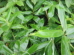
Palú grasses typical of the understory of forests in northern and western Mák’ai.

A Yuyúk’a tree, typical of the evergreen broadleaf forests of eastern Makaigan.

A 'Nguír tree, another common tree in eastern Makaigan.

An Áyurá tree, another common tree in eastern Makaigan.

The flower of the Mlálá tree, highly sort after in eastern Makaigan for its medicinal properties.
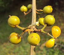
The fruits of the Ńt̗út̗’u tree, commonly eaten as a food source in eastern Makaigan.

The K’ai tree, common in some more forested areas of southern Mák’ai.
A small forest of K'ugan trees in southern Mák’ai.

A field of Ílú flowers in southern Mák’ai.

Baya flowers, common in southern Mák’ai.

Nggúnggan, a common flower plant ubiquitous throughout southern Mák’ai.


-%E6%A8%B9%E9%BD%A2%E7%B4%84700%E5%B9%B4%E3%81%AE%E5%A4%A7%E3%83%92%E3%83%8E%E3%82%ADdaichiji008.jpg)


Mák’ai is also home to incredible faunal diversity. Mák’ai is an important destination for migratory birds from north-western Sazhomara, many of which uniquely migrate to Mák’ai, particularly its southern islands. Important migratory species include the Makai Kula, Red-chested Maiyabird, Great Ocean Ley, Nungai Sea-Ley, and the Southern Yellow Malarai. Mák’ai is also home to a number of non-migratory birds, and has the largest diversity of Makaibirds and Makai Honeyeaters in the world. This latter group is further characterised by its two major evolutionary subgroups - the highly colourful Orubaze Honeyeaters, also called Firebirds, found in southern Mák’ai, and the Northern Honeyeaters found further north. Characteristic species of these groups include the Blue-crowned Red Firebird, Royal Firebird, Ashen Firebird, Makaiganic Needlemouth, Yellow-shrouded Honeyeater, and the Yellow-striped Honeyeater.
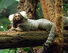
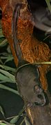
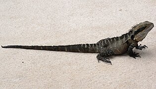
Mák’ai is also home to a diverse range of mammals, including a number of endemic large carnivores. Of these, the most famous are the Ejawan Greatbear and the Makaiganic Tiger, both of which have been very important culturally to the Mák’ai people. Other smaller carnivores include the widespread Aicho fox and the Wuk'ai Mamo, itself endemic to the island of Wuk’ái-la. Other common mammals seen in Mák’ai include the Makaiganic K'aná, the Ejawan Yomolo, and a number of smaller marsupials including Sabel's only extant ratflyer, the Long-tailed Ratflyer. Mák’ai is also home to diverse species of arthropods, including the rare family of Sunspiders, known for their colourful mating displays, and the deadly Ejawan Giant Wasp. Other notable animals endemic to Mák’ai include the Ngalai Water-King, the Makai Rainbow Snake, and the Makaiganic Tigerlizard, the later of which is often exported globally as part of the pet trade. The oceans around Mák’ai are also home to the Northern Grey Whale, which, although not endemic, is commonly seen around Mák’ai.
The Red-chested Maiyabird, a migratory seabird found in southern Mák’ai.
The Makai Kula, an important migratory seabird found in southern Mák’ai.

The Great Ocean Ley, another migratory seabird found in Mák’ai.

The Nungai Sea-Ley.

The Little Makaibird, a Makaibird native to eastern Makaigan.

The Red-backed Makaibird, a striking Makaibird from the central islands of Mák’ai.

The Blue-crowned Red Firebird, native to southern Mák’ai.

The Royal Firebird, another native of southern Mák’ai.

The Ashen Firebird, also native to southern Mák’ai.

The Makaiganic Needlemouth, a species of Northern Honeyeater native to eastern Makaigan.

The Yellow-shrouded Honeyeater, another Northern Honeyeater native to western Makaigan.
The Yellow-striped Honeyeater, native to western Makaigan.

The Ejawan Greatbear, a large carnivore culturally important to the eastern Mák’ai and Kto peoples.

The Makaiganic Tiger, a tiger species endemic to Mák’ai and the country's national emblem.

A Wuk'ai Mamo, an endemic cat to the island of Wuk’ái-la.
A Makaiganic K'aná, a common grazing animal in Mák’ai.
The Ejawan Yomolo, another culturally important animal to the Mák’ai.
The Long-tailed Ratflyer, Sabel's only extant ratflyer, endemic to Mák’ai.
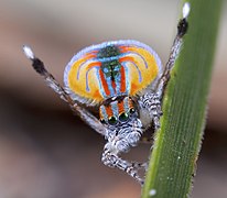
The Golden Sunspider, a species of Sunspider endemic to Mák’ai.

The Ejawan Giant Wasp, a deadly species of wasp endemic to Ejawe.
The Ngalai Water-King, a notable lizard species endemic to Mák’ai.

The Makai Rainbow Snake, a snake species endemic to Mák’ai and an important cultural symbol to the Kto.
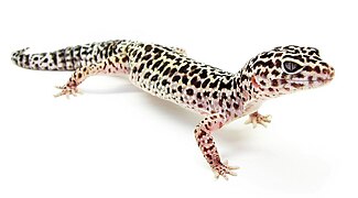
The Makaiganic Tigerlizard, endemic to Mák’ai although exported globally as a pet.

A Northern Grey Whale breaching the water in the Ejawan Sea.


_Photograph_by_Shantanu_Kuveskar.jpg)

-_Male_(Breeding)_on_Kapok_(Ceiba_pentandra)_in_Kolkata_I_IMG_1893.jpg)


.jpg)


.jpg)


Politics
Administrative Divisions
- Main Article: Administrative divisions of Mák’ai.
Mák’ai is divided into 28 administrative divisions collectively referred to as d̗agai-d̗ar (singular: d̗agai-d̗a), which form the highest level of subnational federal division in the country. Under the Mák’ai constitution, each of these d̗agai-d̗ar constitute a federal entity with its own local government, head (called a mik’aí in most cases), and court. While each state is subjected to federal law, each state also has its own laws and customs, and vary in the exact extent to which they individually operate.
Each of the 28 d̗agai-d̗ar are themselves divided into several subtypes. 17 of these are states or d̗uruk-d̗ár (D̗D̗) and generally form the d̗agai-d̗ar of central Makaigan with the closest historical ties to the cultural and political centers of Mák’ai in antiquity. 3 of the d̗agai-d̗ar then form autonomous regions (gará-d̗ar yakmaláwurung or GY), which are typically areas with strong cultural and/or ethnic differences from the Mák’ai heartlands. 6 of the d̗agai-d̗ar then form prefectures (kut'alá-d̗ar or KD̗), consisitingly primarily of the Kto states of eastern Makaigan. Prefectures differ from states largely as a result of historic developments in eastern Mák’ai, rather than as a result of actual political differences. The d̗agai-d̗ar of N̗t̗í-la is Mák'ai's sole existing territory (burúk-d̗ar or BD̗), and lacks a number of the privileges of states and other administrative divisions. Finally, the d̗agai-d̗a of Mk'ái is a special administrative region (d̗agai-d̗a tjurák or D̗T). Mk'ái is unique in that it is the only non-federal top level administrative region of Mák’ai, instead being controlled directly by the national government in Mk'ái-t̗ir̗.


| Map | Flag | D̗agai-d̗a | Type | Population | Capital | Image |
|---|---|---|---|---|---|---|

|
File:Baaruu flag.svg | Bárú BÁR |
State (D̗D̗) |
TBD | Míl̗u |  The coast of Bárú's main island. |

|
File:Dhakan flag.svg | D̗akan D̗AK |
State (D̗D̗) |
TBD | L̗áwái-la |  A field in central D̗akan overlooking the southern end of the Makaiganic Mountain Range. |

|
File:Jaawumirr flag.svg | Jáwumir̗ JÁW |
Prefecture (KD̗) |
TBD | Lbak |  Jáwumir̗ is dominated by mountains such as these. |

|
File:K'iirama flag.svg | K'írama K'ÍR |
State (D̗D̗) |
TBD | T̗al̗ái |  Much of the south-western coast of K'írama is dominated by cliffs like these. |

|
File:Kuthuu Baarkiin flag.svg | Kut̗ú Bárkín KBÁ |
Prefecture (KD̗) |
TBD | Kut̗ú Jar̗ar |  Fields such as these are common in the fertile areas of central Kut̗ú Bárkín |

|
File:Kto Ithar flag.svg | Kut̗ú It̗ar KIT̗ |
Prefecture (KD̗) |
TBD | Tjurgúl Kat̗'ái |  The Valley of It̗ar, in southern Kut̗ú It̗ar |

|
File:Kuthuu Mbaa flag.svg | Kut̗ú Mbá KMB |
Prefecture (KD̗) |
TBD | Káwún Jár̗ |  The coast of southern Kut̗ú Mbá. |

|
File:Kuthuu Waraai flag.svg | Kut̗ú Warái KWA |
Prefecture (KD̗) |
TBD | R̗adúr Numir |  The coast of southern Kut̗ú Warái at the westernmost point of the Kto Sea. |

|
File:Laa-dhar yuk flag.svg | Lá-d̗ar Yuk LD̗Y |
State (D̗D̗) |
TBD | Patji |  Overlooking the Western Ocean from Lá-d̗ar Yuk's southernmost island. |

|
File:Laa Mruuk-kiir flag.svg | Lá Mrúk-kír LMK |
Autonomous region (GY) |
TBD | D̗úm |  Much of Lá Mrúk-kír is covered in dense forests like this one. |

|
File:Luuralai flag.svg | Lúralai LÚR |
State (D̗D̗) |
TBD | Pit̗ák |  Lúralai forms much of the agricultural heartland of Mák’ai and is dominated by fields and gentle hills. |

|
File:Lhan Yaawai flag.svg | L̗an Yáwai L̗YÁ |
State (D̗D̗) |
TBD | N̗t̗íwur |  Rock formations of the coast of L̗an Yáwai. |

|
File:Mbai flag.svg | Mbai MBA |
State (D̗D̗) |
TBD | Mbai |  The Makaiganic mountains in northern Mbai, near the border with the Ktoic Confederacy. |

|
File:Mk'aai flag.svg | Mk'ái MKÁ |
Special administrative region (D̗T) |
TBD | Mk'ái-t̗ir̗ |  The skyline of Mk'ái-t̗ir̗, Mák’ai's capital city which occupies most of Mk'ái. |

|
File:NWA flag.svg | Nggáwai w Áyi NWÁ |
State (D̗D̗) |
TBD | Úguwan̗áyi |  Nggáwai w Áyi is dominated in its central region by hard to access mountain areas, such as this one here. |

|
File:Niimirak flag.svg | Nímirak NÍM |
State (D̗D̗) |
TBD | Nggái-t̗ir̗ |  Nímirak is one of the dryest states in Mák'ai and is dominated by rocky, non-arable terrain in much of its northern and central areas. |

|
File:Njurai flag.svg | Njurai NJU |
State (D̗D̗) |
TBD | Rúwun |  View of the Ejawan Sea from the verdant hills of coastal Njurai. |

|
File:Nlaa-Nungaai flag.svg | Nlá-Nungái NNU |
State (D̗D̗) |
TBD | It̗'ak-la |  Nlá-Nungái is home to the largest old-growth forests in Mák'ai, such as this one. |

|
File:Numurraai flag.svg | Numur̗ái NUM |
Prefecture (KD̗) |
TBD | Numur Bárkín |  Much of Numur̗ái is dominated by plains and agricultural land. |

|
File:Nhthii-la flag.svg | N̗t̗í-la N̗T̗L |
Territory (BD̗) |
TBD | Lwung |  N̗t̗í-la is desolate and sparsely populated, located in the far north of Mák’ai |

|
File:Rruk'aaigan flag.svg | R̗uk'áigan R̗UK |
State (D̗D̗) |
TBD | Ár̗ak |  R̗uk'áigan is a mostly agricultural area characterised by relatively flat topography and fields. |

|
File:Rruumawaii flag.svg | R̗úmawaí R̗UM |
State (D̗D̗) |
TBD | Liwu-t̗ir̗ |  The Straight of Tigers seen on the coast of the Nayimir̗ Peninsula |

|
File:Tjuk'aai-la flag.svg | Tjuk'ái-la TJU |
State (D̗D̗) |
TBD | Diráku |  Tjuk'ái-la is a popular tourist destination as a result of its warmer weather and historical importance. |

|
File:T'ulaa flag.svg | T'ulá TUL |
Autonomous region (GY) |
TBD | Gabán̗ |  A T̗’úkai in a forest in central T'ulá. The T'ulá people have long been culturally and political distinct from the Mák’ai, with T'ulá being one of Mák’ai's three autonomous regions. |

|
File:Uuyarung flag.svg | Úyarung ÚYA |
State (D̗D̗) |
TBD | Út̗ir̗ |  Lake Mák'u in southern Úyarung, with a view of the Makaiganic Mountains in the background. |

|
File:Wuk'aai-la flag.svg | Wuk'ái-la WKL |
Autonomous region (GY) |
TBD | Wárala |  The mountains of central Wuk'ái-la, with the endemic Daughter-of-Wuk'ái flower in the foreground. |

|
File:Wuurrunga flag.svg | Wúr̗unga WÚR̗ |
State (D̗D̗) |
TBD | Wk'á |  A ruined farm house in the far north of Wúr̗unga, in a region known as The Fingers. |

|
File:Yaawurung flag.svg | Yáwurung YÁW |
State (D̗D̗) |
TBD | Málakai |  Yáwurung is home to some of the last remaining giant forests in Mák'ai and is an important area of ecological conservation. |
Economy

- Main article: Economy of Mák’ai.
Mák’ai is the TBD largest economy global and the largest economy in Ejawe, having a total estimated GDP (PPP) of $1,005,692,831 in 475.tk, averaging $24,128 per capita. This puts it ahead of TBD but behind TBD globally. The Mák’ai economy is relatively underdeveloped for a country of its size but is rapidly growing, being the TBD fastest growing economy globally. Mák’ai's economic stagnation is due largely to the political instability and conflicts of the last century, with the solidification of power in the hands of Mar̗uk K’úr̗ai in 477.tk heralding an era of rapid and unprecedented economic development. K’úr̗ai's free-market policy, combined with significant government investment in infrastructure projects, has seen the rapid industrial development of a number of rural Mák’ai cities, including notably Lbak and Pit̗ák. Mass urban migration has also skyrocketed since K’úr̗ai's rise to power, largely as a result of expansive infrastructure projects in cities like Mk'ái-t̗ir̗, which were almost completely rebuilt following the emergence of the new regime. Economic inequity is a major issue between rural and urban centres in Mák’ai, with the wealth gap gradually increasing as a result of government policy.
The Mák’ai economy largely consists of primary and some secondary industries, with the largest economic sectors consisting of agriculture, mining, and manufacturing respectively. As a result of the country's size, Mák’ai has access to a number of important natural resources, particularly iron and precious metals in the Makaiganic Mountain Range. Much of the land in western and southern Makaigan is also highly fertile, and such is home to the country's major agricultural industries. Mák’ai is a global exporter of wheat and other cereal goods, many of which are grown in southern Makaigan. As a result of the concentration of both of these industries in southern and western Makaigan, it is this part of Mák’ai which forms the country's industrial heartlands.
Outside of Makaigan, lumber and agriculture form minor industries in the west of the country, particularly in the highly wooded states of Nlá-Nungái and T'ulá. Tourism is a major industry in the southern Mák’ai islands, whose more tepid climate and historical interest make them popular tourist destinations, particularly from other Ejawan states. Energy is another medium-sized industry in Mák’ai and consists primarily in the extraction of oil and coal from the northern seas and Makaiganic mountains respectively. Gradually, tertiary industries are becoming more prominent in the Mák’ai economy as the country becomes more politically stable, and is centred around financial and academic services in the countries largest cities. In particular, cities such as Mk'ái-t̗ir̗ and Kut̗ú Jar̗ar are becoming popular destinations for international students as a result of the growing global recognition of their universities. It is widely believed that, as the Mák’ai economy continues to develop, these tertiary industries will play an increasingly important role not only in attracting capital, but also in rebuilding international relations between Mák’ai and foreign powers.
The currency of Mák’ai is the Mák’ai T'ula (MKT), whose symbol is ₮. The monetary policy of the Mák’ai Commonwealth is controlled by the Reserve Bank of Mák’ai, which is headquartered in the nation's capital of Mk'ái-t̗ir̗. The exchange rate of Mák’ai T'ula with other global currencies has stabilised in recent years following the market crash and mass inflation of the late 440.tks, but remains a relatively low valued currency in comparison to others globally, such as the Kaishuri Fïdir.
Agriculture, mining, and manufacturing
The Mák’ai economy is primarily based in primary and secondary industries, of which mining, agriculture, and light manufacturing are the largest sectors. Mining for metals is the most expansive and lucrative sector of the Mák’ai economy, with an estimated 40% of the country's GDP coming from metal extraction, and three of the top five largest and wealthiest Mák’ai companies being based in mining. In particular, iron, nickel, copper, and titanium are the most widely exported metals respectively, all of which are found in the Makaiganic Mountain Range. As a result, much of Mák’ai's heavy mining industry is based in western Makaigan, particularly the states of R̗uk'áigan and Úyarung. Úyarung in particular is home to approximately 60% of all mining industry in Mák’ai and as such is one of the country's wealthiest states. Mining for precious metals, such as gold and silver, as well as gems such as Tiyanak and Firestone, also exist to a smaller scale in Nungái-la. In Mák’ai culture, mining is particularly associated with the Ngáarduk gender and the spiritual cult of D̗awun. As such, the act and industry of mining have an important cultural role for Mák’ai people, as does the secondary industry of metalwork.
Light manufacturing and related industries also form a major part of the Mák’ai economy, accounting for approximately 28% of the country's total GDP. Historically, Mák’ai culture was renown for its skill with metalwork and engineering, with this tradition continuing today in the largescale production of high quality metal products. Mák’ai is also a significant global producer of cars, with several major international automobile companies hosting their factories in Mák’ai. Many of these, including the much beloved Mák’ai car companies of Malína and BLN, are based in the northern Ktoic city of Káwún Jár̗, considered to be one of the major industrial centres of Mák’ai. In recent years, Mák’ai has also seen an explosion in the manufacturing of electronics, in particular computer components. Much of this development has been due to the offshoring of production by international companies to Mák’ai, which has in turn helped to rebuild the Mák’ai economy following the devastating Civil War of 445.tk.
Tourism
Energy
Transport
Science and technology
Communications
Demographics
Culture
Notes
- ↑ The term Proto-Mtasai-Ktoic is older and more outdated than the term Proto-Pan-Ejawan, having originally excluded other ethno-cultural groups now considered part of the core Pan-Ejawan group.