Alentejo (An Iberian Spain)
| Alentejo | |||
|---|---|---|---|
| Autonomous community | |||
| |||
|
Anthem: "Himno Alentejano" "Alentejan Hymn" | |||
 Location of the Alentejo within Spain | |||
| Country |
| ||
| Largest city | Ebra | ||
| Capital | Ebra | ||
| Provinces | Ebra, Beja, Portalegre, Grandola | ||
| Government | |||
| • Type | Devolved government in a constitutional monarchy | ||
| • Body | Junta del Alentejo | ||
| • President | Henrique Vallás Escoto (Spanish Socialist Workers' Party) | ||
| Area | |||
| • Total | 31,551 km2 (12,182 sq mi) | ||
| Area rank | 6th | ||
| Population (2016) | |||
| • Total | 704,934 | ||
| • Rank | 15th | ||
| • Density | Bad rounding here22/km2 (Bad rounding here58/sq mi) | ||
| ISO 3166 code | ES-AJ | ||
| Statute of Autonomy | May 7, 1983 | ||
| Official languages | Alentejan, Spanish | ||
| Other languages | Extremaduran, Portugalese, Bordero | ||
| Parliament | Assembly of the Alentejo | ||
| Congress | 10 deputies (out of 350) | ||
| Senate | 10 senators (out of 265) | ||
| HDI (2021) | 0.867 · very high · 17th | ||
| Website |
www | ||
The Alentejo (Spanish: Alentejo; Alentejan: Alêtexo; Portugalese: Alentexo) is an autonomous community of Spain. Its capital city is Ébra, which is also its largest city. Located in the south-western part of the Iberian Peninsula, its northern and eastern borders are partially defined by the Tagus and Guadiana rivers. The autonomous community is formed by four provinces: Ébra, Portalegre, Beja, and Grandola. It is bordered by Portugal to the north east, Valle del Tajo to the north-west, Extremadura to the east, Andalusia to the south-east, and the Algarve to the south.
The name of the region derives from Old Portuguese, being a combination of the words for Beyond (alén), and the Tagus River (Tejo), all together meaning "The Land Beyond the Tagus River". It was also historically called "Amtre-Tejo-e-Odiana", or "Between the Tagus and the Guadiana".
Dimensions
Alentejo's area extends to 31,551 square kilometres (12,182 square miles), which is around 5.27% of the country's area, and it has a population of 704,934, being around 12,5% of the country's population.
Topography
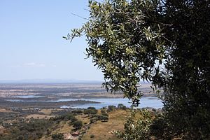
Topographically, the countryside varies from the open rolling plains of the south of Alentejo to the granite hills in the northeast. To feed the water needs of this considerable area, a number of public dams have been constructed, most notably the dam of Portel.
The landscape is primarily one of soft rolling hills and plains, with conspicuous shrubs and the native cork oaks and holly/holm oaks, the established olive trees and grapevines, as well as eucalyptus trees and some native trees. Managed oak landscapes are locally known as montados.[1]
In the north, traditional economic activity tends to be more livestock-based as typified by cattle, sheep, and pig (both white and black) farming. To the south, agriculture tends to be more predominant.
- ↑ Campos, Pablo; Huntsinger, Lynn; Oviedo Pro, Jose Luis; Starrs, Paul F; Diaz, Mario; Standiford, Richard B; Montero, Gregorio, eds. (2013). "Mediterranean Oak Woodland Working Landscapes". Landscape Series. 16. Dordrecht: Springer Netherlands. doi:10.1007/978-94-007-6707-2. ISBN 978-94-007-6706-5. ISSN 1572-7742. Unknown parameter
|s2cid=ignored (help)


