Ayiti
Jump to navigation
Jump to search
| Ayiti | |||
|---|---|---|---|
| State | |||
| State of Ayiti | |||
| |||
| Nickname(s): "The Alpine Island State" | |||
| Motto(s): In Honor of Tradition | |||
| Anthem: A Song for the Island | |||
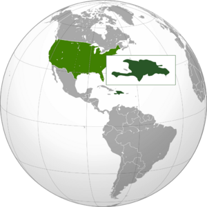
 Map of the United States with Ayiti highlighted | |||
| Country | United States | ||
| Before statehood | Territory of Ayiti | ||
| Admitted to the Union | August 9, 1895 (45th) | ||
| Capital | Carrefour | ||
| Largest city | Santo Domingo | ||
| Largest metro and urban areas | Cape Ayiti | ||
| Government | |||
| • Governor | Horace Fukuyama (R) | ||
| • Lieutenant Governor | Caroline Dean (R) | ||
| Area | |||
| • Total | 29,420 sq mi (76,200 km2) | ||
| Area rank | 41st | ||
| Dimensions | |||
| • Length | 400 mi (600 km) | ||
| • Width | 150 mi (240 km) | ||
| Highest elevation (Mount Duarte) | 10,417 ft (3,175 m) | ||
| Population (2020) | |||
| • Total | 24,517,938 | ||
| • Rank | 3rd | ||
| • Density | 833.37/sq mi (321.77/km2) | ||
| • Median household income | $80,576 | ||
| • Income rank | 10th | ||
| Demonym(s) | Ayitian | ||
| Language | |||
| • Official language | English | ||
| • Spoken language |
Japanese Hokkien Ayitian Apache French Spanish | ||
| Time zone | EST (UTC-5:00) | ||
| • Summer (DST) | EDT (UTC-4:00) | ||
| USPS abbreviation | US-AY | ||
| Traditional abbreviation | AY | ||
Ayiti (Japanese: アイチー Aichī), officially the State of Ayiti (Japanese: アイチー州 Aichī-shǔ) is an island state in the southeastern United States, located approximately 689 miles (1095 km) from the continental US, on the island of Hispaniola. It is one of two island states and the only state located in the Caribbean Sea.
Ayiti consists of the island of Hispaniola, Tortuga Island, Navassa Island, and various smaller islands off the coasts. It is the 41st most extensive and third-most-populous state in the country. The state is divided into 42 counties, with the largest and least-populous being Cordillera County, located in the center of the state and covering the Ayitian Alps.
