The Full Damage Report of Staten Island's North Shore
| Staten Island | |||
|---|---|---|---|
| Borough of New York | |||
| Richmond County, New York | |||
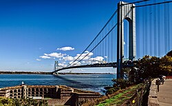
 The Verrazzano-Narrows Bridge as seen from Fort Wadsworth on Staten Island | |||
| |||
| Nickname(s): "The Forgotten Borough" | |||
| Motto(s): The Unexpected Borough | |||
 Map of Staten Island | |||
| Coordinates: | |||
| First Settled | 1661 | ||
| Disincorporation of Staten Island | 17 May 2020 | ||
| Named for |
States General of the Netherlands (Staten Island) Charles Lennox, 1st Duke of Richmond (Richmond County) | ||
| Government | |||
| • Type | Borough | ||
| Area | |||
| • Total | 265 km2 (102.5 sq mi) | ||
| • Land | 152 km2 (58.5 sq mi) | ||
| • Water | 110 km2 (44 sq mi) | ||
| Dimensions | |||
| • Length | 22.0 km (13.7 mi) | ||
| • Width | 12.9 km (8.0 mi) | ||
| Elevation | 100 m (400 ft) | ||
| Population | |||
| • Total | 495,747 | ||
| • Density | 8,618.3/km2 (3,327.5/sq mi) | ||
| Demonym(s) | Staten Islander | ||
| Time zone | UTC-5 (Eastern Standard Time) | ||
| • Summer (DST) | UTC-4 (Eastern Daylight Time) (UTC) | ||
| Area code(s) | 718/347/929, 917 | ||
| Website | www.statenislandusa.com (Defunct) | ||
This devastating incident left an indelible mark on the history of this world, resulting in widespread destruction, loss of life, and long-lasting consequences on regional and global scales.
History behind the Report
While the incident had little effect on the overall infrastructure and development of Staten Island, it did serve as a reminder of the importance of safety protocols and emergency preparedness in densely populated urban areas. The nuclear strikes disrupted communication networks, making it challenging to coordinate emergency response efforts. Transportation systems, such as bridges and tunnels connecting Staten Island to Manhattan, were severely damaged or rendered inoperable, hindering evacuation and aid efforts.
The Scope of Damage
Physical Damage
| Category | Destroyed |
|---|---|
| Roadways and Railway Bridges | 26% |
| Theatres and cinemas | 19% |
| Industry | 34% |
| Healthcare Buildings | 29% |
| Historical monument buildings | 10% |
| Tram infrastructure | 55% |
| Tram rolling stock | 56% |
| Housing | 19% |
| Education | 7% |
| Trees in Parks and Gardens | 76% |
| Roadways Surface | 11% |
Radiation Range (in Kilometers)
| Number of REM (Roentgen equivalent man) | Kilometers Outward |
|---|---|
| 1+ REM | 4.02 km² |
| 1 REM | 5.49 km² |
| 1< REM | 10.06 km² |
Fallout Damage (in Kilometers)
| Fallout RAD/hr | Kilo-meters |
|---|---|
| 1+ RAD/hr | 8 km² |
| 1 RAD/hr | 12 km² |
| 1< RAD/hr | 28 km² |


