Whiterun Hold
- For the capital of the hold, see Whiterun.
| Whiterun Hold | |||
|---|---|---|---|
 | |||
| |||
| Province | Skyrim | ||
| Capital | Whiterun | ||
| Government | |||
| • Jarl | Balgruuf the Greater | ||
| • Steward | Proventus Avenicci | ||
| Demonym(s) | Vitrinians, Whitelings, Plainsmen | ||
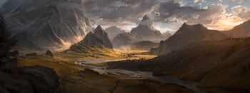
Whiterun Hold (Nordic: Hvitrinnhald; Cyrodilic: Vitrinia), also known as White Hold (Hvitrhald) or simply Whiterun, is a region (hold) that covers most of central Skyrim. The hold capital is at Whiterun, situated on the plains by the eponymous White River.
Geography
Whiterun Hold, located in central Skyrim, encompasses the city of Whiterun and its surrounding plains in the valley of the White River; the Western Plains, including Blackmoor, Rorikstead, and the headwaters of the Hjaal; the southerly Bleak and Brittleshin ranges down to Riverwood Forest and the town of Riverwood; and the Hrothgar Mountains, topped by the Greybeard monastery.
Plains of Whiterun
The eastern plains, centered around the city of Whiterun itself, lie roughly east of the Western Watchtower, south of Whitewatch Tower, west of Hrothgar and north of Riverwood Forest. The White River flows along the eastern edge of the plains.
The vast western plains begin around the Western Watchtower. The fortified settlement of Blackmoor is the only major settlement in the eastern part, except for the occasional giant camp or bandit hideaway. An inselberg known as Lone Mountain rises west of Blackmoor, and small springs to its north mark the source of the Hjaal River. The main road from Blackmoor bends sharply south, avoiding the mountain and instead passing near to Brittleshin Pass and a rocky crossroads area known as the Great Henge (close to the border town of Granite Hill) before curving northwest, through patches of farmland, to Rorikstead. It then extends north through a steep, narrow valley, before forking off to Hjaalmarch and the Reach.
The terrain of the Western Plains is more akin to moorland or tundra than grassland. Trees are scarce, and the land is pockmarked with creeks, craters, pools, caves, and rocky outcrops, as well as ancient ruins and mysterious burial mounds.
Bleaks and Brittleshins
- Main article: Bleaks and Brittleshins
These mountain ranges form a natural border between Whiterun Hold in the north and Falkreath Hold in the south. They are traditionally divided into two sub-ranges: the easterly Bleak Mountains (or Bleaks), overlooking the White River; and the westerly Brittleshin Hills (or Brittleshins), overlooking Lake Ilinalta. The rocks here are rich in iron and copper.
Riverwood Forest
The pine forest here, while reminiscent of neighboring Falkreath's, is sparser and constrained to the White River Valley, which cuts through the mountains, dividing the Bleaks from Hrothgar. Riverwood is located on a wider section of the stream, in the shadow of Bleak Falls Barrow. A small trail leads up to Helgen.
Hrothgar
- Main article: Hrothgar (region)
The towering mountains of Hrothgar form the easternmost part of Whiterun Hold, although there is some overlap with Falkreath and the Rift. The Hrothgar region has sometimes been considered a hold in its own right, owing to its geographical and political isolation from the rest of Skyrim. Functionally a northern branch of the Jeralls, the Hrothgar Mountains include the highest peak in the known world, the Monahven,[1] home to the ancient monastery of High Hrothgar.
History
Whiterun Hold once extended over a much broader area, especially in the First Era under Jarl Gjalund, and later under Olaf One-Eye.
In the late Third Era, Whiterun Hold was troubled by an organization known as the Hörme, a cult devoted to Potema Septim.
Whiterun initially declared neutrality in the Stormcloak Rebellion, but ultimately sided with the Empire.
References
- ↑ Holdings of Jarl Gjalund. Slafknir the Scribe.


