El Salvador
- This is about the Federation of Central America state. For the former country, see Republic of El Salvador.
| El Salvador | |||
|---|---|---|---|
| State of Central America | |||
 | |||
| |||
|
Motto(s): Dios, Unión, Libertad God, Union, Liberty | |||
|
Anthem: Himno Nacional de El Salvador National Anthem of El Salvador | |||
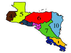
 Location of El Salvador (#3) in Central America | |||
| Capital | San Salvador | ||
| Government | |||
| • Governor | Armando Rodríguez (FA) | ||
| • Vice Governor | Orlando Alvarado (FA) | ||
| • Initiativators |
Alfredo Rosales (U) Lorena Guevara (U) Danilo Ortiz (N) Mauricio Villalta (PSD) Danilo Ceren (PCD) | ||
| • Delegates | 13 delegates | ||
| Area | |||
| • Total | 19,815 km2 (7,651 sq mi) | ||
| Population (2020) | |||
| • Total | 6,416,120 | ||
| • Density | Bad rounding here320/km2 (Bad rounding here840/sq mi) | ||
| Demonym(s) | Salvadoran | ||
| Time zone | Central Time Zone (UTC-06:00) | ||
| Legislature | El Salvador State Legislature | ||
| Upper house | House of Councilors | ||
| Lower house | Legislative Assembly | ||
El Salvador , officially the Federal State of El Salvador (Spanish: Estado Federal de El Salvador), is a state located in the Federation of Central America. It is the seventh largest Central American state in area and the third largest in population. The capital and largest city of El Salvador is San Salvador. It is bordered by Honduras in the north, Victoria in the east, Guatemala in the west, and Pacific Ocean in the south. Distrito Capital, the federal capital district, is a separately governed entity surrounded by El Salvador.
El Salvador was inhabited by the ancient cultures of Olmecs, Lenca, the Mayans, and then the Cuzcatlecs. The Spanish Empire conquered the territory in the 1500s AD and ruled it as part of the viceroyalty of New Spain, based out of Mexico City. The Spanish had little influence on the daily life of the people in the Central American isthmus. In 1821, it became part of independent Mexico, and in 1823 it seceded as the Federal Republic of Central America, becoming fully independent in 1841 as the Republic of El Salvador. The republic unified into the Federation of Central America in 1986 after the signing of Treaty of Sonsonate that indicates the end of Central American crisis. In 2002, the department of La Union became a part of the newly-created federal state of Victoria.
History
Geography
Climate
Flora and fauna
Demographics
Ethnic groups
Languages
Religions
Government and politics
Executive
Legislative
Judicial
Administrative divisions
| No | Name | Seat | Region |
|---|---|---|---|
| 1 | Ahuachapán | Ahuachapán | Occidental |
| 2 | Cabañas | Sensuntepeque | Centro |
| 3 | Chalatenango | Chalatenango | Occidental |
| 4 | Cuscatlán | Cojutepeque | Centro |
| 5 | La Libertad | Santa Tecla | Occidental |
| 6 | La Paz | Zacatecoluca | Centro |
| 7 | Morazán | San Francisco Gotera | Oriental |
| 8 | San Miguel | San Miguel | Oriental |
| 9 | San Salvador | Delgado | Centro |
| 10 | San Vicente | San Vicente | Centro |
| 11 | Santa Ana | Santa Ana | Occidental |
| 12 | Usulután | Usulután | Oriental |
| 13 | San Salvador Special City | N/A | Centro |
Political party strength
Culture
Education
Economy
Agriculture
Tourism
Culture
Architecture
Music
Dance
Symbols
| Insignia | Symbol | Binomial nomenclature |
|---|---|---|
| Official state bird | ||
| Official state fish | ||
| Official state flower | ||
| Official state song | ||
| Official state tree |
See also
| This page uses material from the Wikipedia page El Salvador, which is released under the Creative Commons Attribution-ShareAlike 3.0 Unported License (view authors). |

