Sonora: Difference between revisions
Jump to navigation
Jump to search
m (4 revisions imported) |
Centrist16 (talk | contribs) |
||
| Line 109: | Line 109: | ||
{{S-ttl|title = [[List of Sierran provinces, states, and areas by date of admission to the Union|List of K.S. PSAs by date of admission to the Union]] | {{S-ttl|title = [[List of Sierran provinces, states, and areas by date of admission to the Union|List of K.S. PSAs by date of admission to the Union]] | ||
| years = Admitted on August 7, 1907 (21st)}} | | years = Admitted on August 7, 1907 (21st)}} | ||
{{S-aft|after = [[Eureka]]}} | {{S-aft|after = [[Eureka (province)|Eureka]]}} | ||
{{S-end}} | {{S-end}} | ||
<!-- | <!-- | ||
Latest revision as of 14:37, 9 September 2023
| State of Sonora | |||||
|---|---|---|---|---|---|
| — Province of Sierra — | |||||
| |||||
| Nickname(s): The Saguro Province (official) | |||||
|
Motto(s): Semper excelsius (English: "Always higher") | |||||
| Provincial song(s): "Pride of Sonora" | |||||
| Official language(s) | English, Spanish | ||||
| Demonym | Sonoran(s) | ||||
| Capital (and largest city) | Tucson | ||||
| Area | Ranked 18th | ||||
| • Total |
16,646 sq mi (43,113 km2) | ||||
| Population | Ranked 16th | ||||
| • Total | 1,872,356 (2020) | ||||
| • Density |
112.48/sq mi (43.43/km2) Ranked TBD | ||||
| Elevation | |||||
| • Highest point |
Chiricahua Peak 9,763 ft (2,976 m) | ||||
| • Lowest point |
Great Salt Lake 650 ft (198 m) | ||||
| Admission to the Union | August 7, 1907 (21st) | ||||
| Lord Superintendent | TBD | ||||
| Governor | Wilhelmina Kendrick | ||||
| Lieutenant Governor | TBD | ||||
| Legislature | Sonora Provincial Legislature | ||||
| • Upper house | Senate | ||||
| • Lower house | House of Representatives | ||||
| K.S. Senators |
Curtis Worsley (R) Jason Nicholls (R) Alvin Johnston (L) | ||||
| K.S. House delegation |
7 MPs 2 Libertarians 2 Democratic-Republican 1 Royalist 1 Christian Democrat | ||||
| Time zone |
Mountain Time Zone UTC –7 | ||||
| Abbreviations | SO, KS-SO., KS-SO., SON, Son. | ||||
|
| |||||
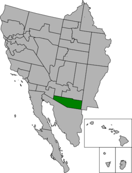
Sonora, officially the State of Sonora, is a Sierran province located in Southeastern Sierra. With a population of 1,872,356 recorded in the 2020 census, Sonora is the 21st most populous PSA in the Kingdom. It is the 18th largest PSA in the country with a total area of 16,646 square miles (43,113 km2). Its capital and largest city is Tucson.
It shares borders with Maricopa and Cornerstone to the north; with West New Mexico to the east; with South Sonora to the south; and with Imperial and Pacífico Norte to the west.
Etymology
Geography
Topography
Climate
Flora and fauna
History
Demographics
Racial and ancestral makeup
Religion
Languages
Culture
Economy
Infrastructure
Freeways
Major freeways
Rail and bus
Airports
Government and politics
Overview
Executive
Legislative
Judicial
Counties and municipalities
Law enforcement
CAS and federal representation
Education
Sports
Symbols
See also
| Preceded by | List of K.S. PSAs by date of admission to the Union Admitted on August 7, 1907 (21st) |
Succeeded by |
| Attribution notices | ||||||||||
|---|---|---|---|---|---|---|---|---|---|---|
|


