Central Valley
| Province of Central Valley (en) Valle Central (es) Vallée Centrale (fr) Sentral Lambak (tn) 中央谷地 (zh) Tỉnh Xanh-trô Va-lì (vn) 센트럴밸리 (kr) セントラル・バレー州 (ja) Zentraltal (de) | |||||
|---|---|---|---|---|---|
| — Province of Sierra — | |||||
| |||||
| Nickname(s): The Parks Province (official), The Natural Province, The Sea-to-Peak Province, The Breadbasket of Sierra, The Ash Tree Province, The Poetry Province | |||||
|
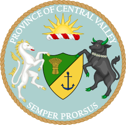
Motto(s): Semper prorsus (Latin: "Always forward") | |||||
| Provincial song(s): "Central Valley, Here I Come" | |||||
| Official language(s) | |||||
| Demonym | Central Valleyen(s) | ||||
| Capital (and largest city) | Fresno | ||||
| Area | Ranked 6th | ||||
| • Total |
26,240 sq mi (67,961 km2) | ||||
| Population | Ranked 11th | ||||
| • Total | 2,109,141 (2010) | ||||
| • Density |
80.37/sq mi (31.03/km2) Ranked 12th | ||||
| Elevation | |||||
| • Highest point |
Mount Whitney 14,505 ft (4,421 m) | ||||
| • Lowest point |
Death Valley -262 ft (-86 m) | ||||
| Admission to the Union | November 27, 1858 (10th) | ||||
| Lord Superintendent | Abagail Masters | ||||
| Governor | Woody Caprioglio (R) | ||||
| Lieutenant Governor | Giovanny Esparza (R) | ||||
| Legislature | Central Valley Legislature | ||||
| • Upper house | Provincial Senate | ||||
| • Lower house | Legislative Assembly | ||||
| K.S. Senators |
Cherzong Vang (DR) Mercedes Briones (DR) Joaquin Nunes (DR) | ||||
| K.S. House delegation |
8 total commoners 3 Democratic-Republicans 2 Royalists 2 Christian Democrats 1 Social Democrat | ||||
| Time zone |
Pacific Time Zone UTC –8/UTC –7 | ||||
| Abbreviations | CV, CV, KS-CV, CNV, Cn-Vl | ||||
|
| |||||
| Central Valley symbols | |
|---|---|
 | |
 | |
| Living insignia | |
| Amphibian | Western spadefoot |
| Bird | Yellow-billed magpie |
| Butterfly | Gulf fritillary |
| Fish | Central Valley Steelhead |
| Flower | Baby blue eyes |
| Grass | Purple needlegrass |
| Insect | Achemon sphinx moth |
| Mammal | Sierra ground squirrel |
| Reptile | Western aquatic garter snake |
| Tree | Valley oak |
| Inanimate insignia | |
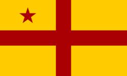
| Colors | Yellow, red |
| Song | "Central Valley, Here I Come" |
| Provincial route marker | |
 | |
| Part of a series on the provinces, states, areas, and territories of Sierra | |
Central Valley is a province located in the Styxie region of Central Western Sierra. The province is the 6th largest by area, and the 11th most populous. Central Valley is bordered to the north with San Francisco, Santa Clara, and San Joaquin, to the east with Clark, to the south with Kings and the Inland Empire, and to the west with the Pacific Ocean. Its capital and largest city is Fresno. It was admitted on November 27, 1858 as the 10th province in order of admission.
The eastern half of the province is defined primarily with major mountain ranges and narrow valleys. Both Central Valley's and the entire country's highest and lowest points: Mount Whitney and Death Valley respectively, are located here. The two geographic extremes are only separated apart from each other by approximately 87 miles. The center of Central Valley is situated in the midsection of the eponymous valley, namely the southern portion of San Joaquin Valley. The western half is mostly hilly, featuring modest mountain ranges and river plains along the Pacific coast. Six national parks and forests (Death Valley National Park, Inyo National Forest, Kings Canyon National Park, Sequoia National Forest, Sequoia National Park, and Sierra Nevada National Forest), as well as over thirty national recreational areas, provincial parks, provincial forests, and wildlife reserves are all located in Central Valley, a fact reflected through the provincial's official name, "The Parks Province".
Central Valley was the traditional homeland of the Yokuts, the Mono, the Ohlone, and other various Amerindian peoples prior to European exploration and subsequent colonization. All of Central Valley alongside much of modern Sierra were claimed by the Spaniards during the 17th century. Although the Spaniards noted Central Valley's natural landscape and suitability for agriculture, it remained largely undeveloped and uninhabited (with the notable exception of the City of Monterey) until Mexico gained independence and assumed control over the region. Under the Mexican government, significant amounts of land were sold to private citizens and soldiers as ranchos. Following the Mexican-American War, Central Valley witnessed sustained settlement and significant agricultural development. When the California Republic became reorganized as the Kingdom of Sierra, Central Valley was admitted as a province on the founding day. Virtually all of Central Valley was occupied by the Republicans during the Sierran Civil War before it was liberated completely in 1877.
Unlike its immediate neighbors, Central Valley's economy has remained predominantly driven by agriculture and forestry. Tourism, fishing, and energy are also other significant industries in the province. It is the largest producer of raisins and figs in Anglo-America, and is also a significant producer in cotton, rice, alfafa, citrus, peaches, plums, nectarines, almonds, and livestock (mainly cattle).
Etymology
The province is named after the prominent geographic landmark known as the Central Valley which spans across seven different provinces from Plumas in the north to Kings in the south. The valley was given its name due to its extensiveness and centrality in the Kingdom, flanked between rolling hills of the Sierra Coast Ranges to the west and the Sierra Nevada to the east. The geographic Central Valley itself runs through the center of the province, but less than a quarter of the valley's total area is accounted for in the province. In order to distinguish the province from the valley, the province is often referred to as Central Valley Province, whereas the valley and region is variously referred to as Geographic Central Valley, the Central Valley, or its alternative names, such as the Great Valley or the Golden Empire.
Nicknames
The official provincial nickname for Central Valley is "The Parks Province". The province is known for its protected natural areas, forests, and parks, which includes six national parks, including Death Valley National Park and Sequoia National Park. It also has thirty additional provincial parks and natural reserves, which attracts millions of locals and tourists alike annually. The nickname was adopted officially by the Central Valley Provincial Legislature on June 19, 1988. Another nickname, "The Natural Province" is also used to evoke the natural landscape and geographical variety of the province, which includes coastal beaches, chaparral hills, grasslands, alpine and tundra mountains, and dry deserts. Central Valley is topographically varied as exemplified by the nickname "The Sea-to-Peak Province" as it contains both of Sierra's extreme points, Mount Whitney (its highest point at over 14,000 feet above sea level) and Badwater Basin (its lowest point at 262 feet below sea level).
Geography
Overview
Central Valley is located at the confluence between two major regions: the Styxie and the Southwest Corridor, and may be considered a part of either under certain definitions and context, moreso with the former. According to the K.S. Royal Bureau of Census, Central Valley is located in Western Central Sierra. It borders San Francisco, Santa Clara, and San Joaquin to the north; Clark to the east; Kings and the Inland Empire to the south; and the Pacific Ocean to the west. With a total area of 26,240 square miles (67,691 km2), Central Valley is larger than Lithuania and slightly smaller than the European country of Georgia. It is the 6th largest PSA in the Kingdom overall.
The province is divided into 5 counties with 157 cities, with its largest county by area being Bishop County.
Topography and terrain
Much of the western two-thirds of the province is located within the geographic Central Valley, a vast region of flat grasslands which spans beyond the province from Tahoe to Kings. This region is separated from the western coast and the eastern portion of the province by mountain ranges: the Southern Coast Ranges (part of the Sierra Coast Ranges) for the former and the Sierra Nevada for the latter.
Contrary to its popular depiction as being flat farmland, Central Valley has one of the most diverse landscapes in the Kingdom of Sierra, ranging from hilly, desolate desert, low-lying grasslands, and sandy beaches to forested canyons and cragged, snow-capped mountains.
Climate
Ecology
Flora and fauna
History
Pre-Sierran period
Early Sierran period
20th century
Contemporary period
Demographics
Racial and ancestral makeup
Religion
Languages
Culture
Art and literature
Music
Sports
Economy
Technology
Agriculture
Tourism
Taxation and budget
Infrastructure and transportation
Energy
Roads
Major highways
Rail and public transit
Airports
Water
Government and politics
Overview
Central Valley is a parliamentary representative democracy which is headed by the Lord or Lady Superintendent, the Queen's viceregal representative, and administered by the Governor, who is elected by peers from the Central Valley Legislative Assembly. The government of Central Valley is structured and organized principally by the Constitution of Central Valley, which is modeled roughly after the original constitution of the California Republic, and may be amended by plebiscite. It guarantees various civil liberties and civil rights of the people, and establishes a government which consists of three branches: executive, legislative, and judicial. It operates under the Westminster model of government, similar to the federal government, and as a consequence, the Central Valley Legislature is the most powerful and influential of the three branches. Since the executive and legislative branches are partially fused, the provincial governor is a member of the Central Valley Legislative Assembly and is elected amongst their peers. All of Central Valley's provincial laws are codified in the Central Valley Code of Statutes.
Executive
Legislative
Judicial
Law
Counties, cities, and towns
Political party strength and ideologies
Federal and CAS representation
Education
Primary and secondary education
Colleges and universities
Public
Private
Symbols
See also
 |
Pacific Ocean • |
• |

| |
| Pacific Ocean | ||||
| ||||
| Pacific Ocean • |
| Preceded by | List of K.S. PSAs by date of admission to the Union Ratified the K.S. Constitution on November 27, 1858 (10th) |
Succeeded by |


