Washumko
| Province of Washumko | |||||
|---|---|---|---|---|---|
| — Province of Sierra — | |||||
| |||||
| Nickname(s): The Lonely Province (official), The Offroad Province | |||||
|
Motto(s): Deo optimo maximo (English: To the best and greatest God) | |||||
| Provincial song(s): "Washumko, Our Washumko" | |||||
| Official language(s) | English | ||||
| Demonym | Washumkite(s) | ||||
| Capital | Elko | ||||
| Largest city | Reno City | ||||
| Area | Ranked 3rd | ||||
| • Total |
39,470 sq mi (102,227 km2) | ||||
| Population | Ranked 26th | ||||
| • Total | 613,473 (2020) | ||||
| • Density |
15.54/sq mi (6.00/km2) Ranked TBD | ||||
| Elevation | |||||
| • Highest point |
Ruby Dome 11,392 ft (3,472 m) | ||||
| • Lowest point |
Pyramid Lake 3,796 ft (1,157 m) | ||||
| Admission to the Union | June 13, 1914 (23rd) | ||||
| Lord Superintendent | TBD | ||||
| Governor | George R. Wallace | ||||
| Lieutenant Governor | TBD | ||||
| Legislature | Washumko Provincial Legislature | ||||
| • Upper house | none | ||||
| • Lower house | none | ||||
| K.S. Senators |
Marcus Gutierrez (R) Edwin Wollenberg (R) Dan Jervis (R) | ||||
| K.S. House delegation |
2 commoners 2 Royalists | ||||
| Time zone |
Pacific Time Zone UTC –8/UTC –7 | ||||
| Abbreviations | WA, KS-WA., KS-WA., WAS, Was. | ||||
|
| |||||
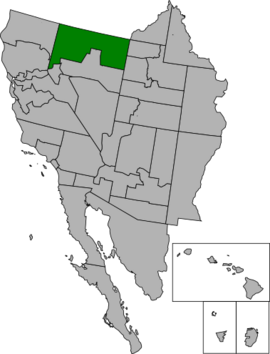
Washumko, officially the Province of Washumko, is a Sierran province located in Northeastern Sierra. With a population of 613,473 recorded in the 2020 census, Washumko is the 26th most populous PSA in the Kingdom. It is the 3rd largest PSA in the country with a total area of 39,470 square miles (102,227 km2). Its capital is Elko and its largest city is Reno City. Most of Washumko is a sparsely-populated desert with small towns, with the exception of the southwest, which is the location of the Reno City urban area.
It shares borders with the Astorian state of Ochoco to the north and their mutual tripoint with the Deseretian area of New Oneida to the northeast; with the Deseretian area of Morganland and Juab to the east; with the Sierran provinces of Reno and Eureka to the south; and with the Sierran provinces of Shasta and Plumas to the west.
Etymology
Geography
Topography
Climate
Flora and fauna
History
Demographics
Racial and ancestral makeup
Religion
Languages
Culture
Economy
Infrastructure
Freeways
Major freeways
Rail and bus
Airports
Government and politics
Overview
Executive
Legislative
Judicial
Counties and municipalities
Law enforcement
CAS and federal representation
Education
Sports
Symbols
See also
| Preceded by | List of K.S. PSAs by date of admission to the Union Admitted on August 1, 1901 (23rd) |
Succeeded by |


